Landscape rehabilitation in Velvary—how we are doing!
Published: Oct 21, 2024 Reading time: 8 minutes Share: Share an articleWithin our LIFE WILL project, the village of Velvary is the location of one of three pilot sites where we are regenerating damaged landscapes and adapting them to climate change. These villages are gradually becoming better protected against natural events such as flash floods.

The LIFE WILL - Water in Landscape and Soil project has been running for two years. Each of its realisations has been a long and complex journey. We have pursued each with landscape architects and local government representatives, humanities researchers, farmers, volunteers and, above all—local people. The latter best know their landscape and are directly interested in its meaningful development. In implementing LIFE WILL we weigh each step carefully so that at the end of the project, there is a quality outcome that will truly benefit everyone.
Let's take a look at what designing landscaping actually looks like in such a project with the help of landscape designer Hana Stuchlík Kašpaříková.
Setting the brief is crucial
As the townof Velvary was a partner in LIFE WILL from the beginning. Initially, the project was primarily aimed at the village's administrative area. However, landscape problems in Velvary are often the result of measures absent in parts of the territory or connected municipalities. The decision to address the entire catchment area of the Svodnica River (11.6 km2), was therefore crucial. It includes the territory of Velvary, its districts of Ješín, Velké and Malé Bučina, and the municipalities of Neuměřice, Nelahozeves, Kamenný Most, Olovnice, Uh, Osluchov, Lešan, and Zeměch u Kralupy nad Vltavou.
We are gradually establishing cooperation with the municipalities. The mayors of Velvar and Neuměřice are now key partners for us. However, we have also negotiated with the mayor of Olovnice and the mayor of Kamenný Most.
Site survey and other supporting documents
The main part of the work is based on a detailed survey of the entire catchment area, which I walked over the course of five days. I used freely available map files and data from local key players as background information. Together with the field survey, they then formed the basis for designing individual measures in the landscape. We return to the area regularly as it changes throughout the year.
The field survey helped to identify problematic areas threatened by wind or water erosion:
- Water erosion is particularly evident in the agricultural valleys that lack permanent grassland.
- Erosion is a natural process in the landscape. But we aim to slow it.
- Wind erosion blows away fine particles that help form the fine texture that is essential for soil fertility. This means farmers end up ploughing rock in some places.
- The drought in the area is so severe that cracks are forming on agricultural land.
- We also have land in the catchment where land reclamation in the form of drainage has taken place. The sites are identified in the study we received from the Vltava River Basin Authority.
- There are traces of voles in the area. In a landscape with large meadows without plantations, they have nowhere to hunt their prey. They don't even have that much space to nest.
- As part of the survey, we have identified sites with larger garbage dumps. Often they are on land where there could be tree planting. For example, ravine paths are filled in, and new roads are created in the fields..
- Invasive species, such as knotweed and milkweeds, often grow locally.
- The problem of litter in the landscape persists. Garbage is dumped or flows into the Svodnica riverbed, which then becomes clogged.
- Part of the area is also a hunting ground. The game eats young plants, and there are hunters' resting places on almost every corner. They are often not made of natural materials and remain in the area after their decay.
I also found worthwhile places:
- Because the area is so large, we have different types of soil.
- The Svodnice River rises in several places. We are trying to work with such places.
- We are located in an area with a rich history of fruit growing, so the remains of fruit trees, especially pear and apple trees, are visible in the landscape.
- Apart from farmers, hunters and beekeepers are other key players in the territory. Therefore, we try to promote biodiversity in the plantation designs by sowing rich meadow mixtures or by diversifying the species of trees and shrubs so that they are also honey-bearing.
- Even though the area is intensively used, there are islands from which native plant species can spread. These are forest stands but also remnants of meadows.
- There are also a number of new plantings in the area that need to be supported with additional care.
The project involved anthropologists and the public
At the beginning of the project, we identified local farmers, landowners and engaged residents. We interviewed social anthropologists Markéta Zandlová, Alžběta Wolfová and Barbora Nohlová from Charles University. With anonymised data from the interviews, a document was drafted from which I drew information.
For example, the residents confirmed what I felt while walking through the landscape—that it is inaccessible to them because a first-class road cuts it off. They also described the runoff of topsoil, the drought and the wind.
The evidence from the mapping and surveys and the initial proposals were then presented to the public. In a subsequent workshop, local people were given the opportunity to comment and express their preferences.
We now have to commission an arborist to carry out maintenance work in the form of felling and trimming at-risk trees. This will be followed up with a planting plan to bring the avenues back into the landscape.
How do we proceed?
We base ourselves on the spatial plans and other studies, such as the Study of runoff conditions in the Bakovský Brook basin - Slánsko-Velvarsko area prepared for the Vltava River Basin Authority.
- In Neuměřice and Ješín, comprehensive land improvements were carried out. These resulted in the arrangement of land and the preparation of the so-called Common Facilities Plan. The plan deals with the design of the road network and the territorial system of ecological stability in the form of the designation of land for biocorridors and biocentres. We are taking advantage of the paths proposed here and are moving towards their implementation.
- We are also working to implement some of the proposed green belts, particularly on municipal land. And where there is no municipal land, we are negotiating with the owners and trying to arrange implementation.
- We are negotiating with farmers about planting windbreaks and also wetlands—at the moment, only in the area of Neuměřice, as the region has not yet been digitised.
- With the Land Office, which has land in the area, we are also dealing with planting proposals and, in part, with the revitalisation of the Svodnica (also in the Neuměřice cadastre).
- Cooperation with the Regional Administration and Maintenance of Roads of the Central Bohemia Region is key for us. We have prepared a passport of greenery (i.e. localisation and assessment of the condition of trees, shrubs and their groups) along the roads and have a proposed care plan for the existing greenery. We have provided the representative of the organisation with all the data, and we are also cooperating with the local environmental department and the building authority.
- We now have to commission an arborist to carry out maintenance work in the form of felling at risk and trimming existing trees. This will be followed up with a planting plan to bring the avenues back into the landscape.
Officialdom and drawings
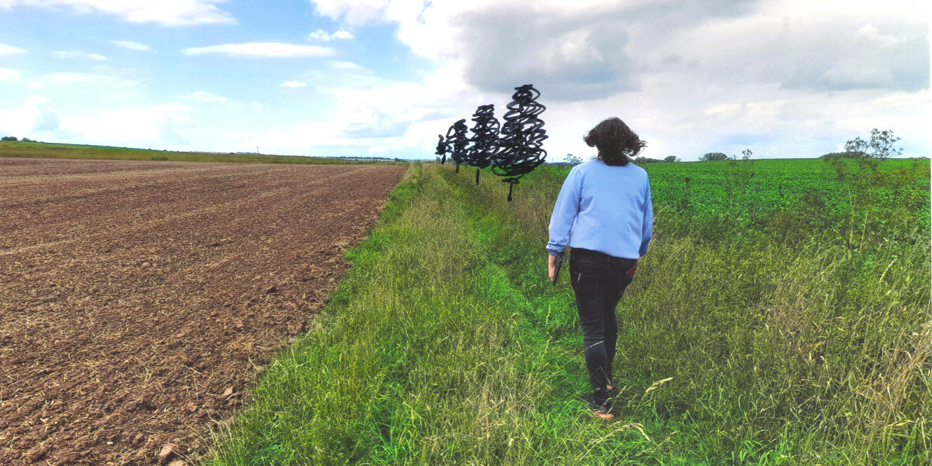
For each landscape measure, we prepare project documentation according to the Building Act. But when we approach landowners (especially farmers), we often come up with proposals drawn on a map or in photographs by hand to help them visualise the desired change.
(The slider can be moved right and left to reveal the "before" and "after".)
- This private land, farmed by farmers, tends to become waterlogged every year. We are negotiating to create a drying pond on the property. To the left of the picture is the bed of the Svodnica River, along which the municipality is currently constructing roads. For the road, we have ordered a Živa clover grass mixture, which should withstand the passage of agricultural equipment.
- In the area of Ješín (which falls under Velvary), the restoration of a dirt road and planting areas was proposed as part of the above-mentioned common facilities plan. In addition, we would like to implement tree planting here.
- The Class III road between Velvary and Neuměřice belongs to the Central Bohemia Region. We have agreed with the manager of the decayed alley, the Administration and Maintenance of Roads of the Central Bohemian Region, that we will inventory the trees and bushes. Each tree was given a label containing, its species, its perspective and further planting interventions. We set the goal to take care of the trees within the care plan and to plant new ones. This was discussed with both the Administration and the farmers.
- The design of the windbreaks is also based on a wind erosion hazard map, which was created specifically for this site and considers the existing vegetation barriers. However, we are also communicating with the farmers in developing the proposals and addressing the need for them to remain on the land. This is an illustrative photograph of an example of a windbreak that would be semi-permeable.
- Example of young tree planting on land designated in the Comprehensive Land Improvement Plan for Common Facilities in Ješín
- Example of landscape transformation during tree planting along regional roads in Ješín and Kamenný Most


